


Maison

CABGAUCHER
User
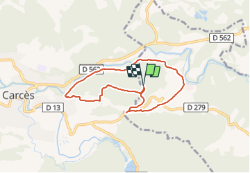

Length
7.3 km

Max alt
207 m

Uphill gradient
136 m
Km-Effort
9.1 km

Min alt
113 m

Downhill gradient
137 m
Boucle
Yes
Creation date :
2022-03-28 13:18:47.0
Updated on :
2022-03-28 14:35:34.962
1h16
Difficulty : Medium

FREE GPS app for hiking
 SityTrail
IGN / Geographical institutes
SityTrail Plus
The world is yours!
About
Trail Walking of 7.3 km to be discovered at Provence-Alpes-Côte d'Azur, Var, Le Thoronet. This trail is proposed by CABGAUCHER.
Positioning
Country:
France
Region :
Provence-Alpes-Côte d'Azur
Department/Province :
Var
Municipality :
Le Thoronet
Location:
Unknown
Start:(Dec)
Start:(UTM)
274654 ; 4817632 (32T) N.
Comments